Photos from
Field Geology
Photos from
Field Geology
Kurt
Friehauf
Field Geology is a course
where we develop geology skills ... in the field!
We meet during the regular school week, as well as weekends.
Weekend field trips are necessary because we need full days of time for
travel to field project sites and in-depth projects.
Here are a few photos from some of our field excursions. (I only
have photos from a few of our excursions because we're usually working
hard!)
Adirondacks
2009
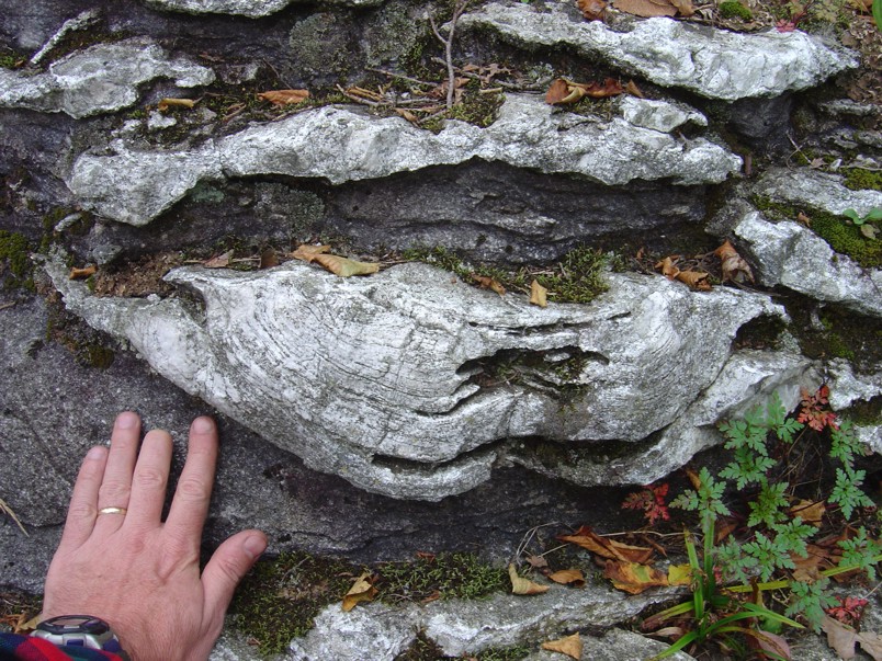 Billion-year old algal mats called stromatolites
preserved in marble - cross section view. The rock was
overturned during the mountain-forming event (orogenesis) so the fossil
pictured here is upside down.
Billion-year old algal mats called stromatolites
preserved in marble - cross section view. The rock was
overturned during the mountain-forming event (orogenesis) so the fossil
pictured here is upside down.
One of the things we learn in Field Geology is how to "read" rocks to
determine their original orientations, as well as the geological
environment that formed them.
 Top view of a stromatolite in Adirondack marble.
The preservation of this specimen is truly remarkable!
Top view of a stromatolite in Adirondack marble.
The preservation of this specimen is truly remarkable!
Centralia,
Pennsylvania
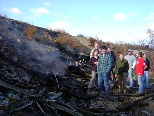 Centralia
is a remarkable place where a fire - reportedly in an old trash pit -
ignited a coal bed. The coal bed began burning underground,
generating heat and smoke. Groundwater that seeps into the soil
also heats up to form steam.
Centralia
is a remarkable place where a fire - reportedly in an old trash pit -
ignited a coal bed. The coal bed began burning underground,
generating heat and smoke. Groundwater that seeps into the soil
also heats up to form steam.
 The logs on
the surface near the fire are charred. Temperatures and
concentrations of CO2 in the soil can be
quite high, locally inhibiting plant growth.
The logs on
the surface near the fire are charred. Temperatures and
concentrations of CO2 in the soil can be
quite high, locally inhibiting plant growth.
 Smoke and steam
escaping the burning coal seam from a vent.
Smoke and steam
escaping the burning coal seam from a vent.
 Close-up of
smoke/steam vent.
Close-up of
smoke/steam vent.
Whaleback, Pennsylvania
 The Bear Valley
Coal Mine (a.k.a. the Whaleback)
is
a famous abandoned strip mine where coal miners removed all the
surface rock and coal right down to the underlying shale.
The Bear Valley
Coal Mine (a.k.a. the Whaleback)
is
a famous abandoned strip mine where coal miners removed all the
surface rock and coal right down to the underlying shale.
 The mine
provides a spectacular exposure of folded rocks. The fold in the
foreground is called an anticline because it crests in the middle with
the limbs of the folds dipping down into the ground away from the
center.
The mine
provides a spectacular exposure of folded rocks. The fold in the
foreground is called an anticline because it crests in the middle with
the limbs of the folds dipping down into the ground away from the
center.
The fold in the background is called a syncline because the fold limbs
dip inwardly toward the center in a valley-shaped pattern.
Recognizing the different types of folds is an important skill for
geologists because rock orientation plays a big role in slope
stability, oil can be found under certain types of folds but not
others, and the orientation and type of folds tell us about the
mountain-forming stresses.
 View looking
right down the axis of a syncline.
View looking
right down the axis of a syncline.
 Lunchtime is a
time to refuel, as well as discuss geologic hypotheses and just
appreciate the beauty of nature around us.
Lunchtime is a
time to refuel, as well as discuss geologic hypotheses and just
appreciate the beauty of nature around us.
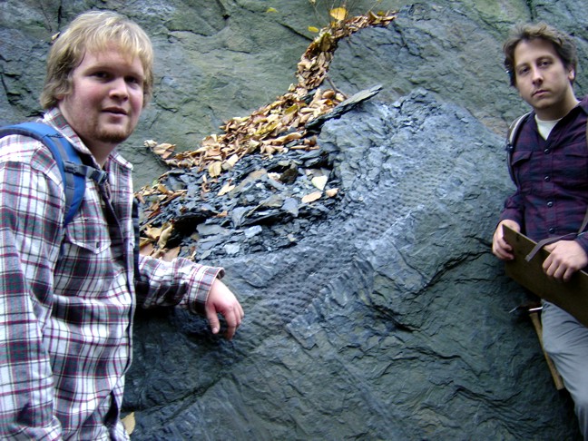
 Max pointing
out a large fossil tree truck in the shale.
Max pointing
out a large fossil tree truck in the shale.
 Measuring the
orientation of rocks in the field is done with a Brunton compass.
The mine has some great surfaces for practicing proper procedure.
Measuring the
orientation of rocks in the field is done with a Brunton compass.
The mine has some great surfaces for practicing proper procedure.
 Harley and
Shane point out plant fossils in the shale. The coal was made by
compression of thick accumulations of plants like this.
Harley and
Shane point out plant fossils in the shale. The coal was made by
compression of thick accumulations of plants like this.
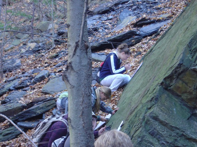
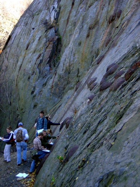
 Mapping into
the cool, shady late afternoon, students measure the orientation of
rock strata pockmarked by large iron concretions (the big bulbous knobs
in this photo).
Mapping into
the cool, shady late afternoon, students measure the orientation of
rock strata pockmarked by large iron concretions (the big bulbous knobs
in this photo).
 Close-up of
iron concretions in shale.
Close-up of
iron concretions in shale.
 Good
geologists record their data on their maps in the field, not back in
the office. Harley demonstrates good technique here.
Good
geologists record their data on their maps in the field, not back in
the office. Harley demonstrates good technique here.
New
Jersey
Highlands
 The contact
between billion-year-old rocks on the left and overlying 500 million
year old limestones on the right. Geologic contacts between rocks
of greatly different ages like this are called unconformities.
The contact
between billion-year-old rocks on the left and overlying 500 million
year old limestones on the right. Geologic contacts between rocks
of greatly different ages like this are called unconformities.
 Large
stromatolites exposed in a limestone knob exposed and polished by
glaciers during the last ice age.
Large
stromatolites exposed in a limestone knob exposed and polished by
glaciers during the last ice age.
 The class
posing with beautiful stromatolites.
The class
posing with beautiful stromatolites.
 Close-up of
dessication cracks in mud between stromatolite mounds. This
demonstrates the carbonate mud was periodically exposed to the air,
drying the mud.
Close-up of
dessication cracks in mud between stromatolite mounds. This
demonstrates the carbonate mud was periodically exposed to the air,
drying the mud.
 Another
close-up of desiccated mud between stromatolite algal bodies.
Another
close-up of desiccated mud between stromatolite algal bodies.
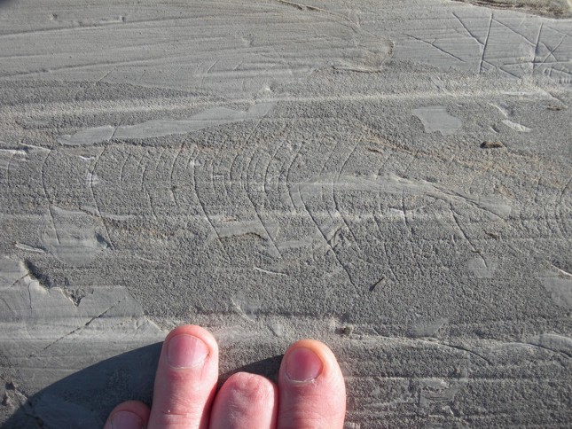
 Glacial
striations are scratches made by the ice as the glacier flowed over the
rock surface. The red pen highlights the direction of ice flow
over the limestone.
Glacial
striations are scratches made by the ice as the glacier flowed over the
rock surface. The red pen highlights the direction of ice flow
over the limestone.
 Stromatolites,
dessication cracks, and glacial striations - all in one photo!
Stromatolites,
dessication cracks, and glacial striations - all in one photo!
 When a rock
fractures and the two blocks of rock slide past one another, the
fracture is called a fault. During fault slippage, minerals can
grow in an orientation that tells us the direction of slippage.
The mineral growths are called slickenlines. These slickenlines
are made of the mineral calcite.
When a rock
fractures and the two blocks of rock slide past one another, the
fracture is called a fault. During fault slippage, minerals can
grow in an orientation that tells us the direction of slippage.
The mineral growths are called slickenlines. These slickenlines
are made of the mineral calcite.
 Limestone
fragments in a fine, sandy carbonate mud matrix tells of an ancient
storm that agitated the ocean waves enough to stir up the ocean floor,
mixing mud/rock fragments with sandy mud.
Limestone
fragments in a fine, sandy carbonate mud matrix tells of an ancient
storm that agitated the ocean waves enough to stir up the ocean floor,
mixing mud/rock fragments with sandy mud.
 Glacial
striations and rip-up clasts
Glacial
striations and rip-up clasts
 These tiny,
round, concentric grains of calcite in the limestone are called
ooids. They form when waves and ocean currents along marine
coasts agitate sand grains while calcium-rich waters deposit calcite on
the rolling grains. This happens today in the Bahamas. I
wonder how much New Jersey resembled the Bahamas many millions of years
ago.
These tiny,
round, concentric grains of calcite in the limestone are called
ooids. They form when waves and ocean currents along marine
coasts agitate sand grains while calcium-rich waters deposit calcite on
the rolling grains. This happens today in the Bahamas. I
wonder how much New Jersey resembled the Bahamas many millions of years
ago.
 Dr. Earl
Verbeek supervises students exploring the Sterling Hill Zinc Mine.
Dr. Earl
Verbeek supervises students exploring the Sterling Hill Zinc Mine.
 Kutztown
University geology students making a map of the rocks in the Sterling
Hill Zinc Mine.
Kutztown
University geology students making a map of the rocks in the Sterling
Hill Zinc Mine.
 Connor standing
as scale by some very high grade zinc ore. Black mineral =
franklinite, white mineral = calcite, red = zincite, brown =
willemite.
Connor standing
as scale by some very high grade zinc ore. Black mineral =
franklinite, white mineral = calcite, red = zincite, brown =
willemite.
 Kelly
carefully examining the mineralogy of the zinc ore bands. She'll
record her observations on the geologic map she is making (in her left
hand).
Kelly
carefully examining the mineralogy of the zinc ore bands. She'll
record her observations on the geologic map she is making (in her left
hand).
 Lauren
recording observations on her geologic map. Good job, Lauren!
Lauren
recording observations on her geologic map. Good job, Lauren!
Monitoring
groundwater
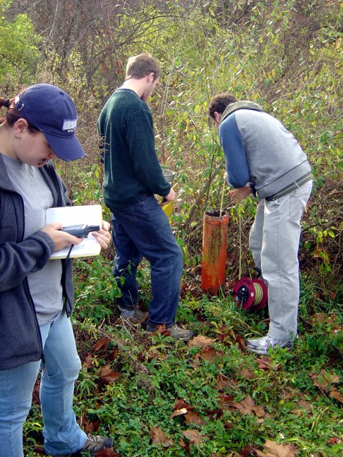 Measuring the
depth to the water table in a groundwater monitoring well with an
electronic tape. The tape has wires running up/down the sides
connected to a battery and a beeper. When the tip of the tape
touches water, the circuit closes and the beeper beeps telling the
geologist they've reached the water table.
Measuring the
depth to the water table in a groundwater monitoring well with an
electronic tape. The tape has wires running up/down the sides
connected to a battery and a beeper. When the tip of the tape
touches water, the circuit closes and the beeper beeps telling the
geologist they've reached the water table.
 Theresa
recording the depth to the water table. Subtracting this depth
from the elevation of the well collar tells us the elevation of the
water table. Determining the elevation of the water table at many
places helps us determine the direction of groundwater flow.
Theresa
recording the depth to the water table. Subtracting this depth
from the elevation of the well collar tells us the elevation of the
water table. Determining the elevation of the water table at many
places helps us determine the direction of groundwater flow.
 Working
together as a team is important for geologists. Kutztown
University geology students are very impressive in this regard.
Working
together as a team is important for geologists. Kutztown
University geology students are very impressive in this regard.
Other Excursions
We went on a bunch of other
field excursions and will go on many more. I'll post more photos
as we do. :-)