Mid-Atlantic Iron Belt Project -
Phase 3 -
Rittenhouse Gap Detailed Geophysical Survey

 Four undergraduates student
involved:
Four undergraduates student
involved:
- Katie Hoefert (senior)
- Lea Burris (senior)
- Laurel Black (senior)
- John Yenchik (senior)
 Project: The
successful linear traverses in the phase 2 reconnaissance study gave
only a
one-dimensional view of the geophysics of the study area.
We did a follow-up study in the Autumn on a
20 x 30 meter plot to prove
that we could use the GPS directly for data location once the tree
canopy was clear and see if we could identify magnetic variations
across a 2-dimensional (map) surface.
Project: The
successful linear traverses in the phase 2 reconnaissance study gave
only a
one-dimensional view of the geophysics of the study area.
We did a follow-up study in the Autumn on a
20 x 30 meter plot to prove
that we could use the GPS directly for data location once the tree
canopy was clear and see if we could identify magnetic variations
across a 2-dimensional (map) surface.  We also wanted to see if we
could identify regions of rock adjacent to the magnetite iron ore veins
that had been depleted of iron due to chemical interaction with the
hot, geothermal waters that deposited the veins and try to put tighter
constraints on the geometry of the veins so that we could say something
about the rock fracturing mechanism that created the veins in the first
place. The success of the 2-dimensional characterization survey
led to expansion of the map area to include a much larger part of the
overall mining district. In all, we’ve collected over 4,000
measurements in the study area to date.
We also wanted to see if we
could identify regions of rock adjacent to the magnetite iron ore veins
that had been depleted of iron due to chemical interaction with the
hot, geothermal waters that deposited the veins and try to put tighter
constraints on the geometry of the veins so that we could say something
about the rock fracturing mechanism that created the veins in the first
place. The success of the 2-dimensional characterization survey
led to expansion of the map area to include a much larger part of the
overall mining district. In all, we’ve collected over 4,000
measurements in the study area to date.
 Results: The
spring of 2003 was a relatively harsh one with weekly snowstorms that
occurred primarily on Thursdays, Fridays, and Saturdays. Satellite positioning also
required pre-dawn work to ge the best GPS resolution.
Results: The
spring of 2003 was a relatively harsh one with weekly snowstorms that
occurred primarily on Thursdays, Fridays, and Saturdays. Satellite positioning also
required pre-dawn work to ge the best GPS resolution.  Although
the weather made for uncomfortable conditions, the snow on the ground
aided in efficient data collection because each data site could be
clearly marked for each successive measurement, thereby allowing us to
take data more quickly. The snow and freezing rain also made the
study a good character-building exercise for all involved. The
data collected suggest we are able to distinguish between “fresh
rocks,” rocks that were chemical altered by the geothermal waters, and
magnetite veins.
Although
the weather made for uncomfortable conditions, the snow on the ground
aided in efficient data collection because each data site could be
clearly marked for each successive measurement, thereby allowing us to
take data more quickly. The snow and freezing rain also made the
study a good character-building exercise for all involved. The
data collected suggest we are able to distinguish between “fresh
rocks,” rocks that were chemical altered by the geothermal waters, and
magnetite veins. 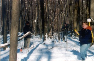 The geometric relationship between
two of the
veins suggests the iron ore occurred as one vein that was broken and
offset by faults later on rather than by infilling of an originally en
echelon fracture set.
The geometric relationship between
two of the
veins suggests the iron ore occurred as one vein that was broken and
offset by faults later on rather than by infilling of an originally en
echelon fracture set.

 Grants: Students
wrote successful Kutztown
University Undergraduate Research grant
proposal that funded travel to the Geological Society of America
Northeast Section meeting in Halifax, Nova Scotia, Canada
Grants: Students
wrote successful Kutztown
University Undergraduate Research grant
proposal that funded travel to the Geological Society of America
Northeast Section meeting in Halifax, Nova Scotia, Canada
 Publication: Hoefert
Catherine M., Burris, Lea, Yenchik, John, Black, Laurel E., and
Friehauf, Kurt C., 2003, Mappin' Without Diggin': An Application of
Magnetometry Techniques in Rittenhouse Gap Mining District in Berks
County, Pennsylvania: Geological Society of America Abstracts
with Programs Vol. 35, No. 3. (All four students traveled and
presented their work with me at this meeting in Halifax, Nova Scotia,
Canada)
Publication: Hoefert
Catherine M., Burris, Lea, Yenchik, John, Black, Laurel E., and
Friehauf, Kurt C., 2003, Mappin' Without Diggin': An Application of
Magnetometry Techniques in Rittenhouse Gap Mining District in Berks
County, Pennsylvania: Geological Society of America Abstracts
with Programs Vol. 35, No. 3. (All four students traveled and
presented their work with me at this meeting in Halifax, Nova Scotia,
Canada)
 Follow-up:
Will try to organize students in the Geophysics course to fill
in gaps in the data as a class project. Pending success of the
overall map, I will propose the Pennsylvania Geological Survey publish
the data as a miscellaneous field investigation.
Follow-up:
Will try to organize students in the Geophysics course to fill
in gaps in the data as a class project. Pending success of the
overall map, I will propose the Pennsylvania Geological Survey publish
the data as a miscellaneous field investigation.

 Four undergraduates student
involved:
Four undergraduates student
involved: Project: The
successful linear traverses in the phase 2 reconnaissance study gave
only a
one-dimensional view of the geophysics of the study area.
We did a follow-up study in the Autumn on a
20 x 30 meter plot to prove
that we could use the GPS directly for data location once the tree
canopy was clear and see if we could identify magnetic variations
across a 2-dimensional (map) surface.
Project: The
successful linear traverses in the phase 2 reconnaissance study gave
only a
one-dimensional view of the geophysics of the study area.
We did a follow-up study in the Autumn on a
20 x 30 meter plot to prove
that we could use the GPS directly for data location once the tree
canopy was clear and see if we could identify magnetic variations
across a 2-dimensional (map) surface.  We also wanted to see if we
could identify regions of rock adjacent to the magnetite iron ore veins
that had been depleted of iron due to chemical interaction with the
hot, geothermal waters that deposited the veins and try to put tighter
constraints on the geometry of the veins so that we could say something
about the rock fracturing mechanism that created the veins in the first
place. The success of the 2-dimensional characterization survey
led to expansion of the map area to include a much larger part of the
overall mining district. In all, we’ve collected over 4,000
measurements in the study area to date.
We also wanted to see if we
could identify regions of rock adjacent to the magnetite iron ore veins
that had been depleted of iron due to chemical interaction with the
hot, geothermal waters that deposited the veins and try to put tighter
constraints on the geometry of the veins so that we could say something
about the rock fracturing mechanism that created the veins in the first
place. The success of the 2-dimensional characterization survey
led to expansion of the map area to include a much larger part of the
overall mining district. In all, we’ve collected over 4,000
measurements in the study area to date.  Results: The
spring of 2003 was a relatively harsh one with weekly snowstorms that
occurred primarily on Thursdays, Fridays, and Saturdays. Satellite positioning also
required pre-dawn work to ge the best GPS resolution.
Results: The
spring of 2003 was a relatively harsh one with weekly snowstorms that
occurred primarily on Thursdays, Fridays, and Saturdays. Satellite positioning also
required pre-dawn work to ge the best GPS resolution.  Although
the weather made for uncomfortable conditions, the snow on the ground
aided in efficient data collection because each data site could be
clearly marked for each successive measurement, thereby allowing us to
take data more quickly. The snow and freezing rain also made the
study a good character-building exercise for all involved. The
data collected suggest we are able to distinguish between “fresh
rocks,” rocks that were chemical altered by the geothermal waters, and
magnetite veins.
Although
the weather made for uncomfortable conditions, the snow on the ground
aided in efficient data collection because each data site could be
clearly marked for each successive measurement, thereby allowing us to
take data more quickly. The snow and freezing rain also made the
study a good character-building exercise for all involved. The
data collected suggest we are able to distinguish between “fresh
rocks,” rocks that were chemical altered by the geothermal waters, and
magnetite veins.  The geometric relationship between
two of the
veins suggests the iron ore occurred as one vein that was broken and
offset by faults later on rather than by infilling of an originally en
echelon fracture set.
The geometric relationship between
two of the
veins suggests the iron ore occurred as one vein that was broken and
offset by faults later on rather than by infilling of an originally en
echelon fracture set. 
 Grants: Students
wrote successful Kutztown
University Undergraduate Research grant
proposal that funded travel to the Geological Society of America
Northeast Section meeting in Halifax, Nova Scotia, Canada
Grants: Students
wrote successful Kutztown
University Undergraduate Research grant
proposal that funded travel to the Geological Society of America
Northeast Section meeting in Halifax, Nova Scotia, Canada Publication: Hoefert
Catherine M., Burris, Lea, Yenchik, John, Black, Laurel E., and
Friehauf, Kurt C., 2003, Mappin' Without Diggin': An Application of
Magnetometry Techniques in Rittenhouse Gap Mining District in Berks
County, Pennsylvania: Geological Society of America Abstracts
with Programs Vol. 35, No. 3. (All four students traveled and
presented their work with me at this meeting in Halifax, Nova Scotia,
Canada)
Publication: Hoefert
Catherine M., Burris, Lea, Yenchik, John, Black, Laurel E., and
Friehauf, Kurt C., 2003, Mappin' Without Diggin': An Application of
Magnetometry Techniques in Rittenhouse Gap Mining District in Berks
County, Pennsylvania: Geological Society of America Abstracts
with Programs Vol. 35, No. 3. (All four students traveled and
presented their work with me at this meeting in Halifax, Nova Scotia,
Canada) Follow-up:
Will try to organize students in the Geophysics course to fill
in gaps in the data as a class project. Pending success of the
overall map, I will propose the Pennsylvania Geological Survey publish
the data as a miscellaneous field investigation.
Follow-up:
Will try to organize students in the Geophysics course to fill
in gaps in the data as a class project. Pending success of the
overall map, I will propose the Pennsylvania Geological Survey publish
the data as a miscellaneous field investigation. 