Model Boundary Conditions
Surface boundary conditions for climate simulation usually consist of, at a minimum, continental configurations, global elevations (i.e. topography and bathymetry), and a vegetation distribution. It has been common for each individual researcher or research group to develop a unique set of boundary conditions for use in their simulations. Thus, unlike simulations of modern climate where there is some degree of comparison possible between simulations completed by multiple research groups, integration of studies across the broader paleoclimate community is hindered, as basic assumptions vary from researcher to researcher. Unless special changes to surface conditions are warranted, this is not the most efficient way to proceed in paleoclimate investigations. This page presents post-publication surface boundary conditions (land-sea distribution, paleotopography, paleobathymetry, and paleovegetation distribution) for various past time periods. These boundary conditions are in NetCDF format and are appropriate for incorporation into numerical studies of Earth's climate.
Early Paleogene (~45 - 65 Ma) Boundary Conditions
Sewall JO, Sloan LC, Huber M, Wing S,
2000, Climate sensitivity to changes in land surface characteristics.
Global and Planetary Change 26 (4): 445-465.
Huber M and Sloan LC, 2001, Heat transport, deep waters, and thermal gradients: Coupled simulation of an Eocene Greenhouse Climate. Geophysical Research Letters 28 (18): 3481-3484.
Additional information on the creation of the bathymetry can be found in Dr. Matthew Huber's Dissertation which is located here.
Land/Sea Distribution, Bathymetry, and Topography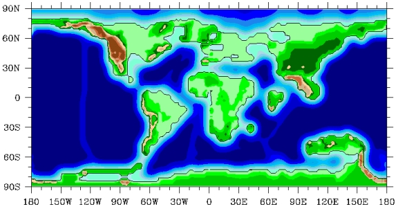 Global Vegetation Distribution
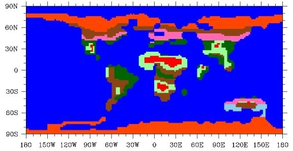
Huber M and Sloan LC, 2001, Heat transport, deep waters, and thermal gradients: Coupled simulation of an Eocene Greenhouse Climate. Geophysical Research Letters 28 (18): 3481-3484.
Additional information on the creation of the bathymetry can be found in Dr. Matthew Huber's Dissertation which is located here.
Land/Sea Distribution, Bathymetry, and Topography
 Global Vegetation Distribution

Early Maastrichtian (~70 Ma +/- 5
Ma) Boundary Conditions
Sewall, JO, van de Wal, RSW, van der Zwan,
K, van Oosterhout, C, Dijkstra, HA, and Scotese, CR, 2007, Climate
model boundary conditions for four Cretaceous time slices, Climate of
the Past, v.3, p. 647 - 657.
Land/Sea Distribution, Bathymetry, and Topography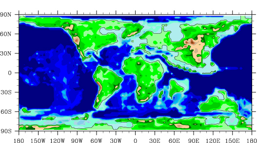
Global Vegetation Distribution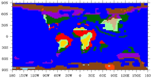
Land/Sea Distribution, Bathymetry, and Topography

Global Vegetation Distribution

Campanian (~80 Ma +/- 5
Ma)
Boundary Conditions
Fricke, HC, Foreman, BZ,
and Sewall, JO, 2009, Integrated climate model-oxygen isotope evidence
for a North America monsoon during the Late Cretaceous, Earth and
Planetary Science Letters, in press, doi:10.1016/j.epsl/2009.10.018
Land/Sea Distribution, Bathymetry, and Topography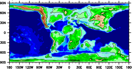
Global Vegetation Distribution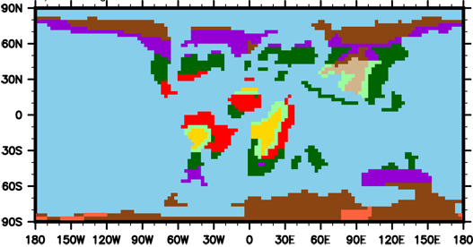
Land/Sea Distribution, Bathymetry, and Topography

Global Vegetation Distribution

Cenomanian/Turonian Boundary (~90 Ma +/- 5
Ma) Boundary Conditions
Sewall, JO, van de Wal, RSW, van der Zwan,
K, van Oosterhout, C, Dijkstra, HA, and Scotese, CR, 2007, Climate
model boundary conditions for four Cretaceous time slices, Climate of
the Past, v.3, p. 647 - 657.
Land/Sea Distribution, Bathymetry, and Topography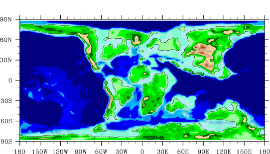
Global Vegetation Distribution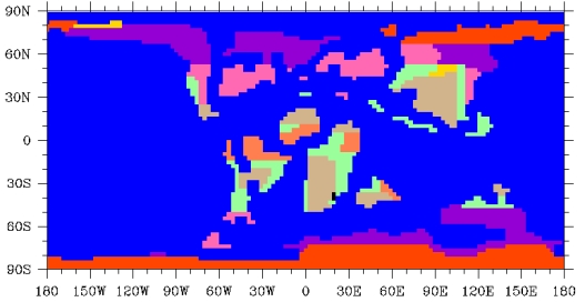
Land/Sea Distribution, Bathymetry, and Topography

Global Vegetation Distribution

Early Albian (~110 Ma +/-
5 Ma) Boundary Conditions
Sewall, JO, van de Wal, RSW, van der Zwan,
K, van Oosterhout, C, Dijkstra, HA, and Scotese, CR, 2007, Climate
model boundary conditions for four Cretaceous time slices, Climate of
the Past, v.3, p. 647 - 657.
Land/Sea Distribution, Bathymetry, and Topography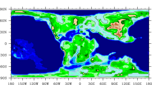
Global Vegetation Distribution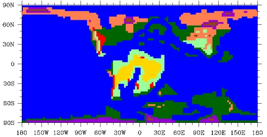
Land/Sea Distribution, Bathymetry, and Topography

Global Vegetation Distribution

Early Aptian (~120 Ma +/-
5 Ma) Boundary Conditions
Sewall, JO, van de Wal, RSW, van der Zwan,
K, van Oosterhout, C, Dijkstra, HA, and Scotese, CR, 2007, Climate
model boundary conditions for four Cretaceous time slices, Climate of
the Past, v.3, p. 647 - 657.
Land/Sea Distribution, Bathymetry, and Topography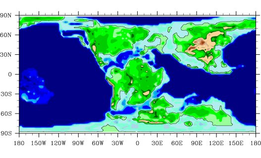
Global Vegetation Distribution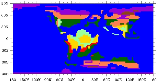
Land/Sea Distribution, Bathymetry, and Topography

Global Vegetation Distribution
