A Simple Climate Definition: Climate is a concept. Climate is the classification of regions based on observed averages in temperature and precipitation, by latitude and position relative to water bodies. We may say, for instance, that coastal regions in a certain latitude range that exhibit a certain annual range in temperature and a certain pattern in precipitation are "Climate X." Climate, as a concept, is a means of classifying, and thus simplifying, the world around us.
Where the oversimplified definition above uses only latitude, position relative to water bodies, temperature and precipitation patterns, many other variables may be used. We, however, will concentrate on latitude, and temperature and precipitation patterns.
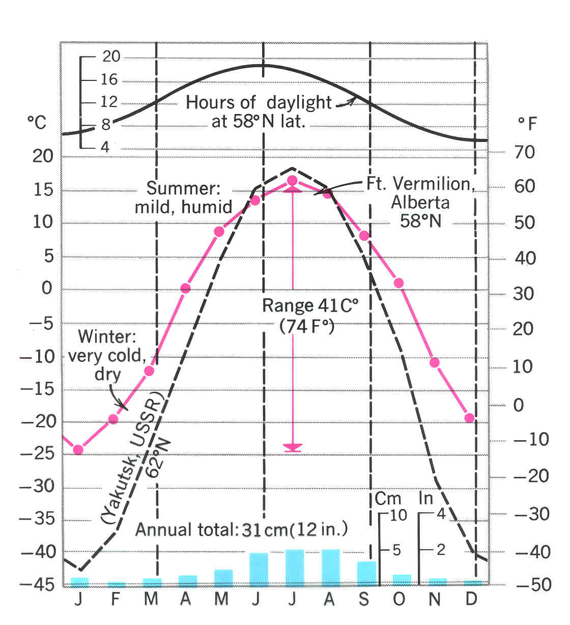
Operationalization: The diagram below is called a Climograph.
The climograph displays month on the x-axis and both temperature and precipitation amounts on the y-axes. The purpose is to visually display seasonal variation in both temperature and precipitation for a given climate.
What to Look For: There is a lot of information on a climograph so we must focus our attention on elements that will make climate recognition a bit more manageable. Here is what I wish for you to look for when studying the assigned climates.Practically Speaking: Practically speaking, memorizing all the data for all the climates is way beyond what you are capable of doing in such a short course section. Rather, I will expect you to be able to identify eight (8) of the Strahler climates based on latitude, position, temperature and precipitation patterns, and "buzz words." I also what you to know WHY climates are the way they are and WHERE they are typically found. The climates you will be tested on are described below. This sequence of climates is found on pages 246 and 247!!1. Latitude Range: you will want to determine if a climate is a high-, mid-, or low latitude. This has a lot to do with temperature patterns.Example Interpretation: We will describe what is shown in the climograph above. The climograph indicates a high latitude climate (curves for two places are shown on the same climograph. Focus your attention on the black curve). This is known since there is a very large annual range in temperature (the difference between the hottest and coldest months). This is also a continental climate for the same reason as above. This is a dry climate. This particular place only gets 31 cm or 12 in of precipitation in a year! This place also gets most of its precipitation in the summer months.2. Position: is the climate coastal or continental, and is it for a high, medium, or low elevation?
3. Temperature Patters: does the climate exhibit a minimal, moderate, or high annual range in temperature; does the climate have well developed seasons?
4. Precipitation patterns: does the climate receive high, medium, or low amounts of rainfall in a year? Does precipitation exhibit a seasonal pattern?
5. Giveaway "Buzz Words:" when possible, I will supply you with "buzz words," climate descriptors that when you read them on a test, you will automatically know which climate is being described.
1. Strahler Climate 1: Wet Equatorial
a. Latitude: 10°N to 10°S so basically equatorial
b. Temp.: high average temperature all year, no seasonal variation
c. Precipitation: high amounts of precipitation all year! These climates form under the ITCZ
d. Major Places: Amazon and Congo Basin (major rainforest areas)2. Strahler Climate 2: Monsoon
a. Latitude: 5° to 25° N or S
b. Temp.: high average temperature with little seasonal variation
c. Experience 180° shifts in seasonal wind direction. Distinct wet/dry seasons. Dry in the winter months and very rainy in the summer months
(remember winter means low solar angle months and summer high solar angle months).
Do you recall which pressure systems regulate the Asian Monsoon? Look 'em up!!
d. Major Places: India and Southern Brazil3. Strahler Climate 4: Dry Tropical
a. Latitude: 15° to 25° N or S
b. Temp.: High average temperature, but a significant annual range
c. Precipitation: Very low precipitation all year because of being under the
Subtropical High all year!! What global circulation cell are the subtropical highs part of?
d. Major Places: The world's major deserts; Sahara and Arabian Deserts; Gibson Desert in Australia.4. Strahler Climate 7: Mediterranean "The World's Best Climate"
a. Latitude: 30° to 40° N or S
b. Position: Coastal climates
c. Temp.: moderate annual range with hot summers and mild winters
d. Precipitation: fairly dry with most precipitation occurring in winter months. The subtropical high causes summers to be dry.
e. Major Places: Coastal regions surrounding the Mediterranean and Southern California!!5. Strahler Climate 9: Dry Mid-latitude
a. Latitude: 35° to 55° N only
b. Temp.: Large annual range in temperature
c. Precipitation: very low annual precipitation do to formation in Rainshadows!
d. Major Places: East of the Sierra Nevadas, Great Plains of the U.S.6. Strahler Climate 10: Moist Continental (Our Climate!!)
a. Latitude: 30° to 55° N
b. Position: continental interiors
c. Temp.: large annual range in temperature with hot summers and cold winters
d. Precipitation: ample precipitation all year with most occurring in summer months
e. Major Places: Eastern U.S., Southern Canada, much of Europe7. Strahler Climate 11: Boreal Forest
a. Latitude: 50° to 70° N only
b. Position: continental interiors
c. Temp.: Greatest Annual Range in Temperature on Earth
d. Precipitation: Very low precipitation. Climate would be desert, but evaporation is too low
e. Special Characteristic: Source region for cP air masses
f. Major Places: Much of Alaska, Siberia, and Scandinavia8. Strahler Climate 12: Tundra
a. Latitude: 60° to 75° N and S
b. Position: coastal
c. Temp.: high annual range but less than Boreal Forest due to being coastal
d. Precipitation: very low precipitation
e. Special Characteristic: region of Permafrost
f. Major Places: North slope of Alaska, Northern Canada, edges of Greenland