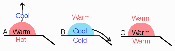
Basic Forms of Stability: There are essentially three types of stability (we will introduce special conditions later). These three are actually rather easy to understand and remember. They are shown below.
In each instance we have a parcel in contact with a surface. Remember the rule: "Air takes on the characteristics of the surface beneath it?" In each case, then, a parcel is formed with the same temperature characteristic as the underlying surface. To accurately determine the stability condition, you must follow this rule:
Always compare the parcel's temperature to that of the surrounding environment and not the other way around!!
A) If an air parcel is warmer than its surrounding environment, then it will be less dense than its surroundings and will rise like a hot air balloon. This is Unstable Air and has the potential for creating storms.Determining Stability Conditions Using DALR, SALR, and ELR: We introduced lapse rates in Tutorial 13. You may wish to go back and refresh your memory as to the values of the DALR and SALR as we will need them shortly. We also showed how the adiabatic lapse rates plot on a diagram. If we add the ELR to such diagrams, we may easily determine the atmospheric stability condition. Let's see what such a diagram would look like and also find out tricks to interpreting the diagram. In the following diagrams, a dashed line is used to indicate the ELR.B) If an air parcel is cooler than its surrounding environment, then it will be denser than its environment and will sink. Think of this situation as a pebble sinking in water. This is Stable Air which generally leads to clear skies.
C) If an air parcel is the same temperature as its surrounding environment, then the parcel will not move of its own accord. This is Neutral Air.

Diagram Features: There are a set of features you need to become familiar with. The ELR always has "Warm" and "Cool" sides to it. Here is what I mean. Temperature increases to the right along the X-axis. I want you to consider the region to the right of the ELR to be the"Warm Region" and the left region to be the"Cool Region". We may prove this idea. Read up the Y-axis to an arbitrary altitude (in this example, where the green line is). We will find out how much dry and saturated air and the environment will have cooled by this altitude. Read straight across along the green line and drop lines down to the X-axis where the green line hits the DALR, SALR, and the ELR. Note that dry air would have cooled the most, the environment the next greatest amount, and saturated air the least. The dry air "D" is on the left of the ELR "E" while the saturated air "S" is on the right of "E." Let's apply this to the first diagram. Here, dry air will cool more rapidly and thus be cooler than the environment at any given level. According to our first diagram, dry air would be Stable. Saturated air would cool more slowly than the environment and therefore remain warmer than the surrounding environment. The first diagram shows this situation as being Unstable.Specific Stability Conditions: The following diagrams depict the various forms of stability that you will be expected to know.Rules: A parcel line plotting to the right of the ELR indicates unstable conditions for that parcel type. A parcel line plotting to the left of the ELR indicates stable conditions for that parcel type.


A Helpful Technique: In Tutorial 12, I mentioned that you may use your right hand to mimic the lapse rate diagram. Let's do it again. Hold your right hand with your palm facing you. Now fold all fingers but your index and middle fingers. There are the DALR and SALR. Now, use your thumb as the ELR. This is your handy-dandy grapher! Try and mimic the stability diagrams immediately above.
A Quick Example: What would the stability condition of a saturated parcel be if the ELR was +6°C / 1 km? Take out your handy-dandy grapher. Where will the ELR plot? You must now recall from Tutorial 12 what the DALR and SALR are numerically. Once you know what they are per 1 km increments, you will be able to plot the given ELR. In this situation, the ELR will plot somewhere between the DALR and SALR; this is called Conditional Stability. The question is, however, what the condition of a saturated parcel will be. The SALR is on the "warm" or unstable side of the ELR so the answer is unstable. You will need to be able to do these kinds of problems on exams.