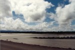
 The
flat jungle lands surrounding Timika are crossed by wide,
sediment-laden rivers. The rivers are braided
due to their sediment load (amount of sand, silt, and gravel being
washed down the channel). These rivers carry a lot of sediment
because they start in very high, steep mountains where the water flows
quickly and erodes the bedrock. The
flat jungle lands surrounding Timika are crossed by wide,
sediment-laden rivers. The rivers are braided
due to their sediment load (amount of sand, silt, and gravel being
washed down the channel). These rivers carry a lot of sediment
because they start in very high, steep mountains where the water flows
quickly and erodes the bedrock. |
| Freeport
Indonesia uses one of the rivers to get rid of ground rock flour
byproducts of mining called "tailings," which is one of the most controversial
issues related to mining there. The basic premise is the
Ajkwa River is naturally very full of sediment due to erosion and so
will carry what sand it can and spread the rest out downstream. Studies
show that very little of the tailings make it all the way down to the
Arafura Sea and that dissolved copper concentrations in the river water
meet Indonesian drinking water standards, but not the standards of
Australia/New Zealand/U.S. (Freeport
response to report) In the lowlands, I could not tell by
just looking at different rivers which river transported tailings and
which was wholly natural and was surprised when shown which was
which! |
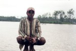
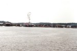  The
Kamoro
Tribe
lives on the river in the lowlands. They build houses on stilts
over the water and fish the rivers for food. When one thinks of
cannibals in New Guinea, the Kamoro were not as aggressive as the Asmat
Tribe to the south, but you get the point. Kal Muller's
website is the place to go if you want to know about the Kamoro,
because he worked/lived with them for almost 10 years (1995-2004). The
Kamoro
Tribe
lives on the river in the lowlands. They build houses on stilts
over the water and fish the rivers for food. When one thinks of
cannibals in New Guinea, the Kamoro were not as aggressive as the Asmat
Tribe to the south, but you get the point. Kal Muller's
website is the place to go if you want to know about the Kamoro,
because he worked/lived with them for almost 10 years (1995-2004). |
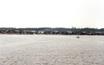
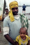
  Although
the Kamoro
Tribe may have traditionally been nomadic hunters/gatherers, many of
the Kamoro living near the port make their living working for Freeport
(and making/selling carved wooden statues). The development of
mining in West Papua brought a lot of change to the region - new
opportunities and wealth, and loss of some of the traditional
culture. Although
the Kamoro
Tribe may have traditionally been nomadic hunters/gatherers, many of
the Kamoro living near the port make their living working for Freeport
(and making/selling carved wooden statues). The development of
mining in West Papua brought a lot of change to the region - new
opportunities and wealth, and loss of some of the traditional
culture. |
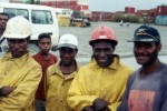
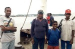
  These
fellows had just got off work when I was visiting the shipping
container facility. They were amused that someone would want to
photograph them and so naturally hammed it up a bit. Friendly
folks, although the language barrier prevented us from swapping our
life stories. These
fellows had just got off work when I was visiting the shipping
container facility. They were amused that someone would want to
photograph them and so naturally hammed it up a bit. Friendly
folks, although the language barrier prevented us from swapping our
life stories. |
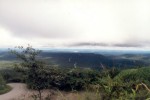 As one travels north, the
flatlands give way to the foothills of the New Guinea Highlands.
The jungle is just as dense, but the topography starts getting
steep. I imagine that on a clear day one might be able to see for
miles out to sea, but it was always overcast when I was on the road up
to the highlands. As one travels north, the
flatlands give way to the foothills of the New Guinea Highlands.
The jungle is just as dense, but the topography starts getting
steep. I imagine that on a clear day one might be able to see for
miles out to sea, but it was always overcast when I was on the road up
to the highlands. |
 The
flat jungle lands surrounding Timika are crossed by wide,
sediment-laden rivers. The rivers are braided
due to their sediment load (amount of sand, silt, and gravel being
washed down the channel). These rivers carry a lot of sediment
because they start in very high, steep mountains where the water flows
quickly and erodes the bedrock.
The
flat jungle lands surrounding Timika are crossed by wide,
sediment-laden rivers. The rivers are braided
due to their sediment load (amount of sand, silt, and gravel being
washed down the channel). These rivers carry a lot of sediment
because they start in very high, steep mountains where the water flows
quickly and erodes the bedrock. 
 The
Kamoro
Tribe
lives on the river in the lowlands. They build houses on stilts
over the water and fish the rivers for food. When one thinks of
cannibals in New Guinea, the Kamoro were not as aggressive as the Asmat
Tribe to the south, but you get the point. Kal Muller's
website is the place to go if you want to know about the Kamoro,
because he worked/lived with them for almost 10 years (1995-2004).
The
Kamoro
Tribe
lives on the river in the lowlands. They build houses on stilts
over the water and fish the rivers for food. When one thinks of
cannibals in New Guinea, the Kamoro were not as aggressive as the Asmat
Tribe to the south, but you get the point. Kal Muller's
website is the place to go if you want to know about the Kamoro,
because he worked/lived with them for almost 10 years (1995-2004).
 Although
the Kamoro
Tribe may have traditionally been nomadic hunters/gatherers, many of
the Kamoro living near the port make their living working for Freeport
(and making/selling carved wooden statues). The development of
mining in West Papua brought a lot of change to the region - new
opportunities and wealth, and loss of some of the traditional
culture.
Although
the Kamoro
Tribe may have traditionally been nomadic hunters/gatherers, many of
the Kamoro living near the port make their living working for Freeport
(and making/selling carved wooden statues). The development of
mining in West Papua brought a lot of change to the region - new
opportunities and wealth, and loss of some of the traditional
culture. 
 These
fellows had just got off work when I was visiting the shipping
container facility. They were amused that someone would want to
photograph them and so naturally hammed it up a bit. Friendly
folks, although the language barrier prevented us from swapping our
life stories.
These
fellows had just got off work when I was visiting the shipping
container facility. They were amused that someone would want to
photograph them and so naturally hammed it up a bit. Friendly
folks, although the language barrier prevented us from swapping our
life stories.  As one travels north, the
flatlands give way to the foothills of the New Guinea Highlands.
The jungle is just as dense, but the topography starts getting
steep. I imagine that on a clear day one might be able to see for
miles out to sea, but it was always overcast when I was on the road up
to the highlands.
As one travels north, the
flatlands give way to the foothills of the New Guinea Highlands.
The jungle is just as dense, but the topography starts getting
steep. I imagine that on a clear day one might be able to see for
miles out to sea, but it was always overcast when I was on the road up
to the highlands. 