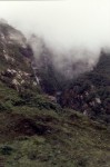
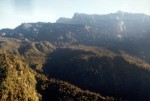
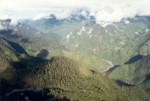
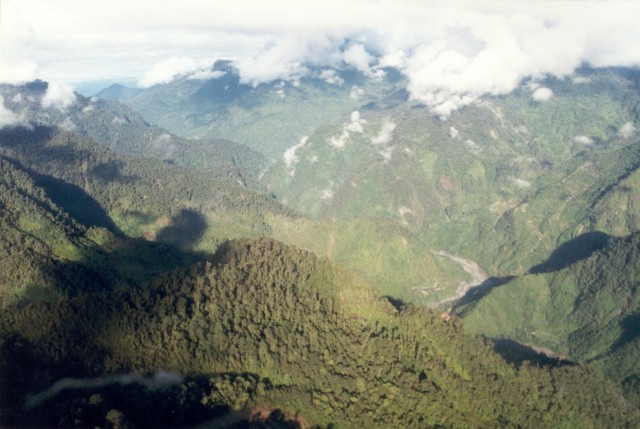
  The Papuan
Highlands are
breathtaking. I'll never forget our first ride up to Tembagapura
with Al Edwards. As is typical, we were socked in with thick fog
for most of the drive up from the lowlands. We passed through a
long tunnel and hit a clear patch on the other side. We couldn't
see far, but we could suddenly see that the ridge dropped off
precipitously on either side. As we encountered more clear
patches, the intensity of the land began repeatedly sucking
involuntary, "Ahh"s out of all three of us. The Papuan
Highlands are
breathtaking. I'll never forget our first ride up to Tembagapura
with Al Edwards. As is typical, we were socked in with thick fog
for most of the drive up from the lowlands. We passed through a
long tunnel and hit a clear patch on the other side. We couldn't
see far, but we could suddenly see that the ridge dropped off
precipitously on either side. As we encountered more clear
patches, the intensity of the land began repeatedly sucking
involuntary, "Ahh"s out of all three of us. |
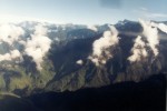
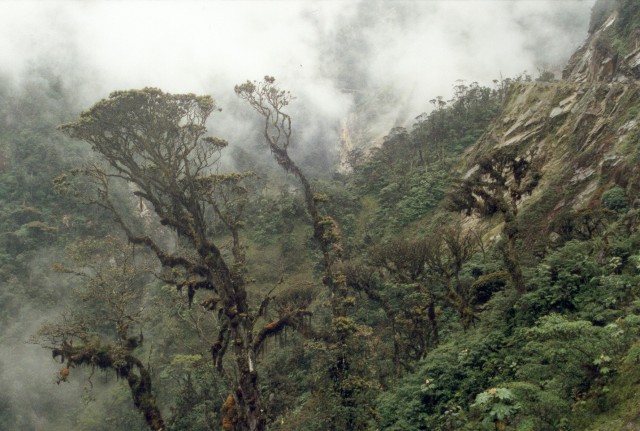
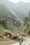  The Highlands area is very steep,
yet plants miraculously cling to the sides. The soil can't be
that thick, but the wet conditions must break down rock at a rate that
keeps up with erosion. The geologists who do the exploration in
the Papuan Highlands are some truly rugged individuals. The Highlands area is very steep,
yet plants miraculously cling to the sides. The soil can't be
that thick, but the wet conditions must break down rock at a rate that
keeps up with erosion. The geologists who do the exploration in
the Papuan Highlands are some truly rugged individuals.
|
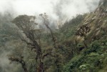
  The jungle highlands reach up to
elevations near 13,000 feet. With increasing elevation, though,
the tree cover gives way to rocky high peaks. The jungle highlands reach up to
elevations near 13,000 feet. With increasing elevation, though,
the tree cover gives way to rocky high peaks. |
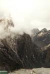
 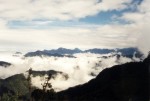 Fog clouds obscure the view like
clockwork. Morning's are commonly clear up until about 10:30 or
11:00 when the clouds begin materializing. Unlike fog in the San
Francisco Bay area where the fog comes rolling in like a wave off the
ocean, fog clouds in New Guinea appear to form in place, grow, and
merge into one big blanket. Fog clouds obscure the view like
clockwork. Morning's are commonly clear up until about 10:30 or
11:00 when the clouds begin materializing. Unlike fog in the San
Francisco Bay area where the fog comes rolling in like a wave off the
ocean, fog clouds in New Guinea appear to form in place, grow, and
merge into one big blanket. |
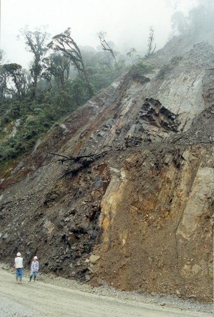
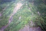  The steep flanks make landslides
common. Sediment naturally erodes off the mountains and chokes
the streams, forming braided rivers. The steep flanks make landslides
common. Sediment naturally erodes off the mountains and chokes
the streams, forming braided rivers. |
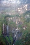 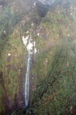 Waterfalls cascade off the steep
mountain flanks. Some waterfalls appear to end in a mist as the
water falls 10's of meters. Waterfalls cascade off the steep
mountain flanks. Some waterfalls appear to end in a mist as the
water falls 10's of meters. |
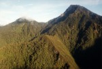
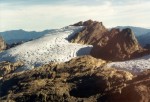 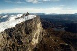 The scenery is even more striking
above the mill level at elevations over 12,000 ft. Here, the
tree-covered slopes give way to rocky peaks with a glacier - a glacier
only 4° south of the equator! The scenery is even more striking
above the mill level at elevations over 12,000 ft. Here, the
tree-covered slopes give way to rocky peaks with a glacier - a glacier
only 4° south of the equator! |
 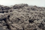 The photo
on the left is a color photograph! The rocky dolomite rock
weathers to form virtually no soil at all, so plants cannot take
root. The terrain is very difficult to climb across, but seeing
country like this makes me daydream of making geologic maps in a land
where all the rocks are exposed with 100% continuity. Yeah,
mapping in such a place would lose the mystery of what lies between
outcrops, but the abundance of constraints on the geology would create
at least as many new puzzles! The photo
on the left is a color photograph! The rocky dolomite rock
weathers to form virtually no soil at all, so plants cannot take
root. The terrain is very difficult to climb across, but seeing
country like this makes me daydream of making geologic maps in a land
where all the rocks are exposed with 100% continuity. Yeah,
mapping in such a place would lose the mystery of what lies between
outcrops, but the abundance of constraints on the geology would create
at least as many new puzzles! |
 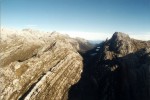 Working in
the mine area is certainly easy on the eyes. The Yellow Valley
Syncline in the carbonate rocks was exposed by glacial erosion (note
the broad U-shaped valley and patternoster lakes). Working in
the mine area is certainly easy on the eyes. The Yellow Valley
Syncline in the carbonate rocks was exposed by glacial erosion (note
the broad U-shaped valley and patternoster lakes). |
  The large
scale geology is beautiful to behold from a helicopter - giant folds,
thrust faults, and blocky igeous intrusions. One of natures real
jewels, however, was yet to come on this trip - Grasberg! The large
scale geology is beautiful to behold from a helicopter - giant folds,
thrust faults, and blocky igeous intrusions. One of natures real
jewels, however, was yet to come on this trip - Grasberg! |

 The Papuan
Highlands are
breathtaking. I'll never forget our first ride up to Tembagapura
with Al Edwards. As is typical, we were socked in with thick fog
for most of the drive up from the lowlands. We passed through a
long tunnel and hit a clear patch on the other side. We couldn't
see far, but we could suddenly see that the ridge dropped off
precipitously on either side. As we encountered more clear
patches, the intensity of the land began repeatedly sucking
involuntary, "Ahh"s out of all three of us.
The Papuan
Highlands are
breathtaking. I'll never forget our first ride up to Tembagapura
with Al Edwards. As is typical, we were socked in with thick fog
for most of the drive up from the lowlands. We passed through a
long tunnel and hit a clear patch on the other side. We couldn't
see far, but we could suddenly see that the ridge dropped off
precipitously on either side. As we encountered more clear
patches, the intensity of the land began repeatedly sucking
involuntary, "Ahh"s out of all three of us.
 The Highlands area is very steep,
yet plants miraculously cling to the sides. The soil can't be
that thick, but the wet conditions must break down rock at a rate that
keeps up with erosion. The geologists who do the exploration in
the Papuan Highlands are some truly rugged individuals.
The Highlands area is very steep,
yet plants miraculously cling to the sides. The soil can't be
that thick, but the wet conditions must break down rock at a rate that
keeps up with erosion. The geologists who do the exploration in
the Papuan Highlands are some truly rugged individuals.
 The jungle highlands reach up to
elevations near 13,000 feet. With increasing elevation, though,
the tree cover gives way to rocky high peaks.
The jungle highlands reach up to
elevations near 13,000 feet. With increasing elevation, though,
the tree cover gives way to rocky high peaks.
 Fog clouds obscure the view like
clockwork. Morning's are commonly clear up until about 10:30 or
11:00 when the clouds begin materializing. Unlike fog in the San
Francisco Bay area where the fog comes rolling in like a wave off the
ocean, fog clouds in New Guinea appear to form in place, grow, and
merge into one big blanket.
Fog clouds obscure the view like
clockwork. Morning's are commonly clear up until about 10:30 or
11:00 when the clouds begin materializing. Unlike fog in the San
Francisco Bay area where the fog comes rolling in like a wave off the
ocean, fog clouds in New Guinea appear to form in place, grow, and
merge into one big blanket.
 The steep flanks make landslides
common. Sediment naturally erodes off the mountains and chokes
the streams, forming braided rivers.
The steep flanks make landslides
common. Sediment naturally erodes off the mountains and chokes
the streams, forming braided rivers.
 Waterfalls cascade off the steep
mountain flanks. Some waterfalls appear to end in a mist as the
water falls 10's of meters.
Waterfalls cascade off the steep
mountain flanks. Some waterfalls appear to end in a mist as the
water falls 10's of meters.
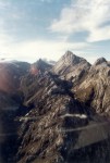
 The scenery is even more striking
above the mill level at elevations over 12,000 ft. Here, the
tree-covered slopes give way to rocky peaks with a glacier - a glacier
only 4° south of the equator!
The scenery is even more striking
above the mill level at elevations over 12,000 ft. Here, the
tree-covered slopes give way to rocky peaks with a glacier - a glacier
only 4° south of the equator! 
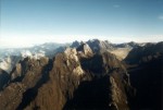
 The photo
on the left is a color photograph! The rocky dolomite rock
weathers to form virtually no soil at all, so plants cannot take
root. The terrain is very difficult to climb across, but seeing
country like this makes me daydream of making geologic maps in a land
where all the rocks are exposed with 100% continuity. Yeah,
mapping in such a place would lose the mystery of what lies between
outcrops, but the abundance of constraints on the geology would create
at least as many new puzzles!
The photo
on the left is a color photograph! The rocky dolomite rock
weathers to form virtually no soil at all, so plants cannot take
root. The terrain is very difficult to climb across, but seeing
country like this makes me daydream of making geologic maps in a land
where all the rocks are exposed with 100% continuity. Yeah,
mapping in such a place would lose the mystery of what lies between
outcrops, but the abundance of constraints on the geology would create
at least as many new puzzles!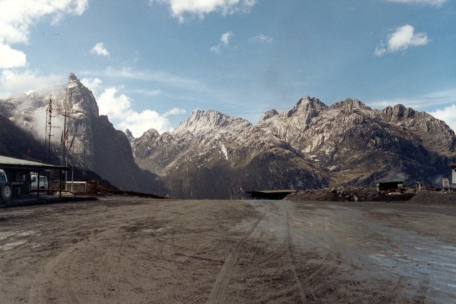
 Working in
the mine area is certainly easy on the eyes. The Yellow Valley
Syncline in the carbonate rocks was exposed by glacial erosion (note
the broad U-shaped valley and patternoster lakes).
Working in
the mine area is certainly easy on the eyes. The Yellow Valley
Syncline in the carbonate rocks was exposed by glacial erosion (note
the broad U-shaped valley and patternoster lakes).
 The large
scale geology is beautiful to behold from a helicopter - giant folds,
thrust faults, and blocky igeous intrusions. One of natures real
jewels, however, was yet to come on this trip - Grasberg!
The large
scale geology is beautiful to behold from a helicopter - giant folds,
thrust faults, and blocky igeous intrusions. One of natures real
jewels, however, was yet to come on this trip - Grasberg!