
 The
water we drink in the
East Penn Valley comes from a water-soaked body of rock called an aquifer. We drill holes down to
aquifers called wells
from which we pump groundwater
to drink, wash, etc.
The
water we drink in the
East Penn Valley comes from a water-soaked body of rock called an aquifer. We drill holes down to
aquifers called wells
from which we pump groundwater
to drink, wash, etc.The water in the aquifer is
originally rainwater and melting snow. These waters seep downward
into the ground and percolate through the soil and fractured bedrock
until they reach the aquifer. Once in the aquifer, water is free
to flow laterally (north/ east/ south/ west/ etc.) instead of just
downward.
Some rocks are
easier for water to flow through than others. The ease with which
water flows through rock is called the rocks permeability.
Highly
permeable
rocks
allow
water
to flow through quickly. Rocks
with low permeability block the underground flow of water - we call
those aquicludes
or aquitards,
depending
on
whether
they
completely
block flow or just slow it down a
lot, respectively.
For rainwater
to get into the an aquifer, it must either fall onto the surface of the
earth in a place covered by permeable rocks, or else seep into the
ground through the permeable bed of a stream. Regions where the
surface rocks are pemeable enough for rainwater to percolate down into
the aquifer are called recharge zones because
they
refresh
the
aquifer
like
recharging a battery (except with water
instead of electic potential).
The Boroughs
(towns) in the Kutztown region know that as the regions population
grows, we will need to draw more water from the aquifer. Also as
the region becomes more developed, people will build buildings, parking
lots, streets, and other very structures with very low permeabilities
that block the recharge zones, preventing the aquifers from receiving
new water to replace that which we drink from wells. Recharge
zones are also places where pollution from the surface can enter and
contaminate our aquifer.
It is wise to
identify these recharge zones so we don't block them up with with
parking lots or allow pollution to ruin our water supply. The
Sourcewater Protection Program is an intiative of our local government
to determine where rainwater enters our aquifer so we can plan where to
build and not to build. The Borough hired a local geological
engineering company (Spotts, Stevens, and McCoy, Inc.) to develop a
hydrogeologic model of the valley. The company partnered with
Kutztown University's geology program to monitor the water level in
wells in the valley so their professional hydrogeologists could better
understand the shape of the water table
in the region and model groundwater flow. It's nice to see the
good that we can do when we all work together.
Several
students worked to measure the water levels in wells around the valley
using an electronic water level tape, as well as a GPS to precisely
locate their measurements. Michele, Dana, and Dee did a great job!
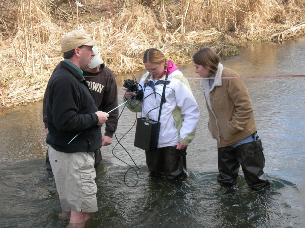 To determining whether Saucony Creek gains water from
the aquifer - what we call a gaining stream - or contributes water to
the aquifer - a losing stream, we measured the amount of flow at
several points along the creek. If the amount of flow, called the
discharge, was greater as we moved downstream, then the Saucony would
be classified as a gaining stream. Conversely, if discharge
decreases downstream, then the Saucony would be a losing stream.
This is an important consideration in developing a hydrogeologic model
of the region.
To determining whether Saucony Creek gains water from
the aquifer - what we call a gaining stream - or contributes water to
the aquifer - a losing stream, we measured the amount of flow at
several points along the creek. If the amount of flow, called the
discharge, was greater as we moved downstream, then the Saucony would
be classified as a gaining stream. Conversely, if discharge
decreases downstream, then the Saucony would be a losing stream.
This is an important consideration in developing a hydrogeologic model
of the region.  We did
this in February when the temperature a couple degrees above freezing,
making it a cold dip in the creek. It wasn't so bad after a
while, though, because the students wore waders and my legs numbed up
after a while. :-)
We did
this in February when the temperature a couple degrees above freezing,
making it a cold dip in the creek. It wasn't so bad after a
while, though, because the students wore waders and my legs numbed up
after a while. :-) We didn't have a fancy top-setting wading rod in
the department at the time, so we made due with a meter stick. No
one can ever accuse me of being anything but cheap!
We didn't have a fancy top-setting wading rod in
the department at the time, so we made due with a meter stick. No
one can ever accuse me of being anything but cheap! What kind of a nut gives a lecture on integration
(calculus) while standing in frigid water? And what kind of
students would listen to such a spiel? Very dedicated ones!
What kind of a nut gives a lecture on integration
(calculus) while standing in frigid water? And what kind of
students would listen to such a spiel? Very dedicated ones! To map
the shape of the water table in the study area, we visited several
dozen residential water wells to measure the depth to water.
Subtracting the depth to water from the elevation of the well gives us
the elevation of the water table. Plotting these elevation data
on a map allows us to make a contour map of the water table and so
predict the hydrologic gradients that drive groundwater flow in the
aquifer.
To map
the shape of the water table in the study area, we visited several
dozen residential water wells to measure the depth to water.
Subtracting the depth to water from the elevation of the well gives us
the elevation of the water table. Plotting these elevation data
on a map allows us to make a contour map of the water table and so
predict the hydrologic gradients that drive groundwater flow in the
aquifer. Michele, Dana,
Mrs. Strauss, and Dee at our first well
Michele holding Dr. Friehauf's portable white board for explaining
things, Dana holding maps and water level tape for measuring depth to
water in well, and Dee holding field notebook and pencil with extra
hard leads (so doesn't smear).
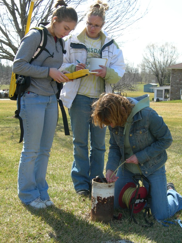 The team worked well together. Each person
had their job and coordinated well with the others. We
periodically traded off duties, too, so everyone had a chance to learn
all of the skills involved.
The team worked well together. Each person
had their job and coordinated well with the others. We
periodically traded off duties, too, so everyone had a chance to learn
all of the skills involved.
