 Potential
porphyry/epithermal
mineralization
on
Mount
Fairplay,
Interior
AlaskaPotential
porphyry/epithermal
mineralization
on
Mount
Fairplay,
Interior
Alaska
Potential
porphyry/epithermal
mineralization
on
Mount
Fairplay,
Interior
AlaskaPotential
porphyry/epithermal
mineralization
on
Mount
Fairplay,
Interior
AlaskaOur hosts on the expedition told us they
knew nothing about the mineral potential of the mountain. With
the goal of assessing the extents of mineralization on the prospect, we
made a geologic map of Mount Fairplay. I love geologic mapping.
 There are few good outcrops on Mount Fairplay - which is
typical of the Alaskan interior. Freeze-thaw action breaks rock
up into chunks ranging from hand-sized to bathtub size. The
arctic conditions also cause the rocks to work their way down the
slopes like very slow-moving rivers and cascades. Mount Fairplay
sheds her skin seasonally like a shaggy
caribou shedding its fur.
There are few good outcrops on Mount Fairplay - which is
typical of the Alaskan interior. Freeze-thaw action breaks rock
up into chunks ranging from hand-sized to bathtub size. The
arctic conditions also cause the rocks to work their way down the
slopes like very slow-moving rivers and cascades. Mount Fairplay
sheds her skin seasonally like a shaggy
caribou shedding its fur.
Nature is full of beautiful things!
 This is
what Mount Fairplay looked like when we were mapping in late May.
The snow drifts were deeper than I am tall, so we worked around
them. That's Dan in the foreground, inspecting a rock.
This is
what Mount Fairplay looked like when we were mapping in late May.
The snow drifts were deeper than I am tall, so we worked around
them. That's Dan in the foreground, inspecting a rock.
 There
was a forest fire up near Delta
Junction - about 100 miles away. The wind carried the smoke
over to Mount Fairplay one day, dramatically decreasing
visibility. We didn't know where the fire was because we didn't
have phones, internet, or long-distance radio. The smoke wasn't
so bad that the smoke irritated our throats and lungs, though, so we
continued working as usual. Later, we ran across some Alaska
state forestry guys who told us the fire was way over near Delta.
The wind blew it all away by early afternoon.
There
was a forest fire up near Delta
Junction - about 100 miles away. The wind carried the smoke
over to Mount Fairplay one day, dramatically decreasing
visibility. We didn't know where the fire was because we didn't
have phones, internet, or long-distance radio. The smoke wasn't
so bad that the smoke irritated our throats and lungs, though, so we
continued working as usual. Later, we ran across some Alaska
state forestry guys who told us the fire was way over near Delta.
The wind blew it all away by early afternoon.
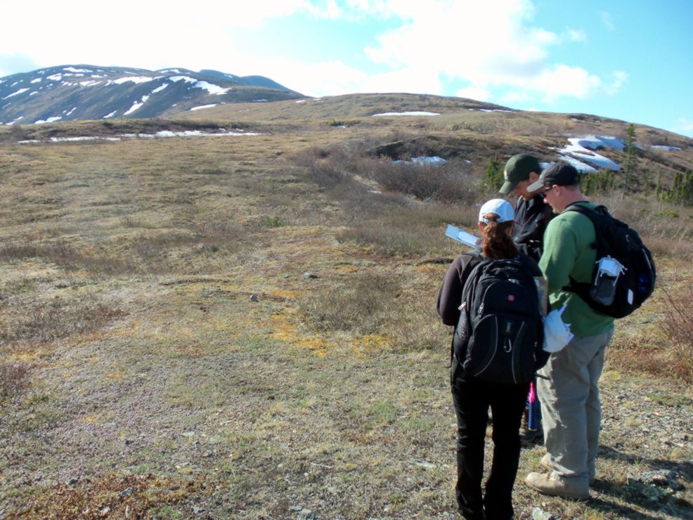 Orienting ourselves for our traverse - one of the keys to
efficient mapping is starting by knowing where you are located, and
never getting lost after that.
Orienting ourselves for our traverse - one of the keys to
efficient mapping is starting by knowing where you are located, and
never getting lost after that.
We used GPS to locate ourselves.
When Melania, Dan, and Ken were doing a traverse without me and the GPS
broke down, they used
their compasses to triangulate their positions.

Hiking up the mountain - life without helicopter assistance is a whole lot slower, but
the exercise is great! I'm no fan of running on a treadmill or
riding a stationary bike, but wilderness hiking is awe-inspiring and a
very palatable means of working out.
 An example of rare, firm outcrop. This cohesive
block of rock could either be solid bedrock, or a large slide
block. The coherent strike and dip of the bedding relative to
other outcrops of the same rock type suggested this was not large block
slide, but actual outcrop.
An example of rare, firm outcrop. This cohesive
block of rock could either be solid bedrock, or a large slide
block. The coherent strike and dip of the bedding relative to
other outcrops of the same rock type suggested this was not large block
slide, but actual outcrop.
 One of the ridge tops had two very distinct kinds of
rocks - on that the black lichen liked to grow on, and another that was
not conducive to lichen growth. A good geologist keeps track of
the relationships between rock type and plant life. Each plant
requires nutrients in different proportions - some tolerate acidic
conditions, others prefer alkaline, and still others need a rich supply
of iron or some other element. Different rock types have
different compositions and so are better/worse places for different
plants to grow on.
One of the ridge tops had two very distinct kinds of
rocks - on that the black lichen liked to grow on, and another that was
not conducive to lichen growth. A good geologist keeps track of
the relationships between rock type and plant life. Each plant
requires nutrients in different proportions - some tolerate acidic
conditions, others prefer alkaline, and still others need a rich supply
of iron or some other element. Different rock types have
different compositions and so are better/worse places for different
plants to grow on.
The tripod in the background is someone's
radio repeater - a device used for extending the range of radio
transmissions.
 A very nice outcrop of volcanic tuff on the ridge
top.
True outcrop is a very welcome thing after tracking down geologic
contacts in loose rock (what geologists term "float").
A very nice outcrop of volcanic tuff on the ridge
top.
True outcrop is a very welcome thing after tracking down geologic
contacts in loose rock (what geologists term "float").
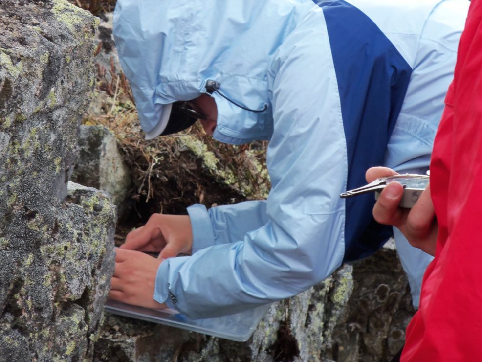 Melania uses a Brunton
compass to measure the orientation of the volcanic tuff beds.
Geologists measure the direction the bedding plane dives down into the
ground (called the dip direction) and the angle of dip (how steeply the
bedding plane dives down). Personally, I usually record the
direction the bed dives down using the "strike," which is perpendicular
to the dip direction. Dr. Malcolm Reeves at the University of
Saskatchewan has a nice
graphic
illustrating
these
measurements here.
Melania uses a Brunton
compass to measure the orientation of the volcanic tuff beds.
Geologists measure the direction the bedding plane dives down into the
ground (called the dip direction) and the angle of dip (how steeply the
bedding plane dives down). Personally, I usually record the
direction the bed dives down using the "strike," which is perpendicular
to the dip direction. Dr. Malcolm Reeves at the University of
Saskatchewan has a nice
graphic
illustrating
these
measurements here.
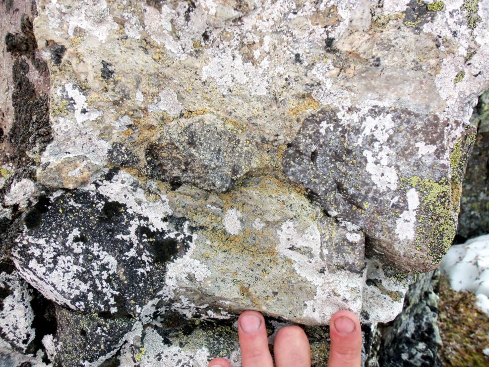 The volcanic tuff had some large fragments set in a
matrix of fine-grained volcanic ash. Fragments of volcanic rock
are collectively called volcanic
tephra. The fragments here would be classified
by
size.
The volcanic tuff had some large fragments set in a
matrix of fine-grained volcanic ash. Fragments of volcanic rock
are collectively called volcanic
tephra. The fragments here would be classified
by
size.
 This
is
an
example
of a different volcanic tuff unit. Note the many
different kinds of rock fragments within the tuff, torn from the throat
of the volcano as magma and volcanic gas explosively erupt from the
volcano.
This
is
an
example
of a different volcanic tuff unit. Note the many
different kinds of rock fragments within the tuff, torn from the throat
of the volcano as magma and volcanic gas explosively erupt from the
volcano.
 Talus
slopes (also known as scree slopes) like this one are common in places
where there is a lot of freeze-thaw action. Water gets into fine
fractures in the rock called joints. When the water freezes at
night, it expands, prying the rock apart into pieces. During the
day, the ice melts, allowing the water to seep deeper into the fracture
or to flow into a new fracture, which it will then pry apart,
too. You can see this effect in your home by putting a water
bottle in your freezer overnight. The sides will bulge when the
ice forms because ice is less dense than liquid water. This
process is called "frost wedging." Freeze-thaw action also slowly
transports this broken rock down the mountain side.
Talus
slopes (also known as scree slopes) like this one are common in places
where there is a lot of freeze-thaw action. Water gets into fine
fractures in the rock called joints. When the water freezes at
night, it expands, prying the rock apart into pieces. During the
day, the ice melts, allowing the water to seep deeper into the fracture
or to flow into a new fracture, which it will then pry apart,
too. You can see this effect in your home by putting a water
bottle in your freezer overnight. The sides will bulge when the
ice forms because ice is less dense than liquid water. This
process is called "frost wedging." Freeze-thaw action also slowly
transports this broken rock down the mountain side.
 Frost
boils
are
places
where the permafrost churns rock up to the surface.
The ground here is covered in soil that rests on top of hard
bedrock. The soil is porous, so water can seep in between the
grains. In permafrost, the water between the grains is frozen ice
that binds the soil grains together. That ice swells and shrinks
- more in some places, less in others. The differences probably
reflect irregularities in the shape of the bedrock-soil interface, the
availability of newly infiltrating water, and groundwater flow in the
bedrock. Frost boils are places where that expanding ice pushes
upward like an underground fountain of frozen soil, carrying rocks up
to the surface.
Frost
boils
are
places
where the permafrost churns rock up to the surface.
The ground here is covered in soil that rests on top of hard
bedrock. The soil is porous, so water can seep in between the
grains. In permafrost, the water between the grains is frozen ice
that binds the soil grains together. That ice swells and shrinks
- more in some places, less in others. The differences probably
reflect irregularities in the shape of the bedrock-soil interface, the
availability of newly infiltrating water, and groundwater flow in the
bedrock. Frost boils are places where that expanding ice pushes
upward like an underground fountain of frozen soil, carrying rocks up
to the surface.
 Because
the
soil
is constantly churning in frost
boils, they are usually only very sparsely vegetated.
Because
the
soil
is constantly churning in frost
boils, they are usually only very sparsely vegetated.
 Here,
a
frost
boil
erupts to the surface and the rocks and soil flow downhill (to the
right). This frost boil occurs in a slight gully with bit of a
slope. Groundwater commonly mimics surface water patterns.
Apparently, permafrost does so, too.
Here,
a
frost
boil
erupts to the surface and the rocks and soil flow downhill (to the
right). This frost boil occurs in a slight gully with bit of a
slope. Groundwater commonly mimics surface water patterns.
Apparently, permafrost does so, too.
 The
freeze-thaw
action
in an arctic environment also forms rivers
of rock. The
blocks of rock that form by frost wedging (scree) slowly work their way
down the mountainside. This happens because the ice lifts the
rock, then as the ice melts, gravity pulls them down the slope.
The
freeze-thaw
action
in an arctic environment also forms rivers
of rock. The
blocks of rock that form by frost wedging (scree) slowly work their way
down the mountainside. This happens because the ice lifts the
rock, then as the ice melts, gravity pulls them down the slope.
 The freeze-thaw action of the arctic not only forms
rivers of scree rock, but also causes the soil itself to flow
downhill. When soil oozes down a slope, we call the process
solifluction (from the Latin word roots sol = soil, fluction = flow).
The freeze-thaw action of the arctic not only forms
rivers of scree rock, but also causes the soil itself to flow
downhill. When soil oozes down a slope, we call the process
solifluction (from the Latin word roots sol = soil, fluction = flow).
 Waves of flowing rock and soil dripping off the mountain
due to solifluction.
Waves of flowing rock and soil dripping off the mountain
due to solifluction.
The high mound on the ridge top is the
remnant of a much broader sheet of volcanic tuff.
 Melania stands near toe of lobe of soliflucting soil and
rock. Look carefully and you will see there's a mound of
disturbed soil at the base of the rock flow.
Melania stands near toe of lobe of soliflucting soil and
rock. Look carefully and you will see there's a mound of
disturbed soil at the base of the rock flow.
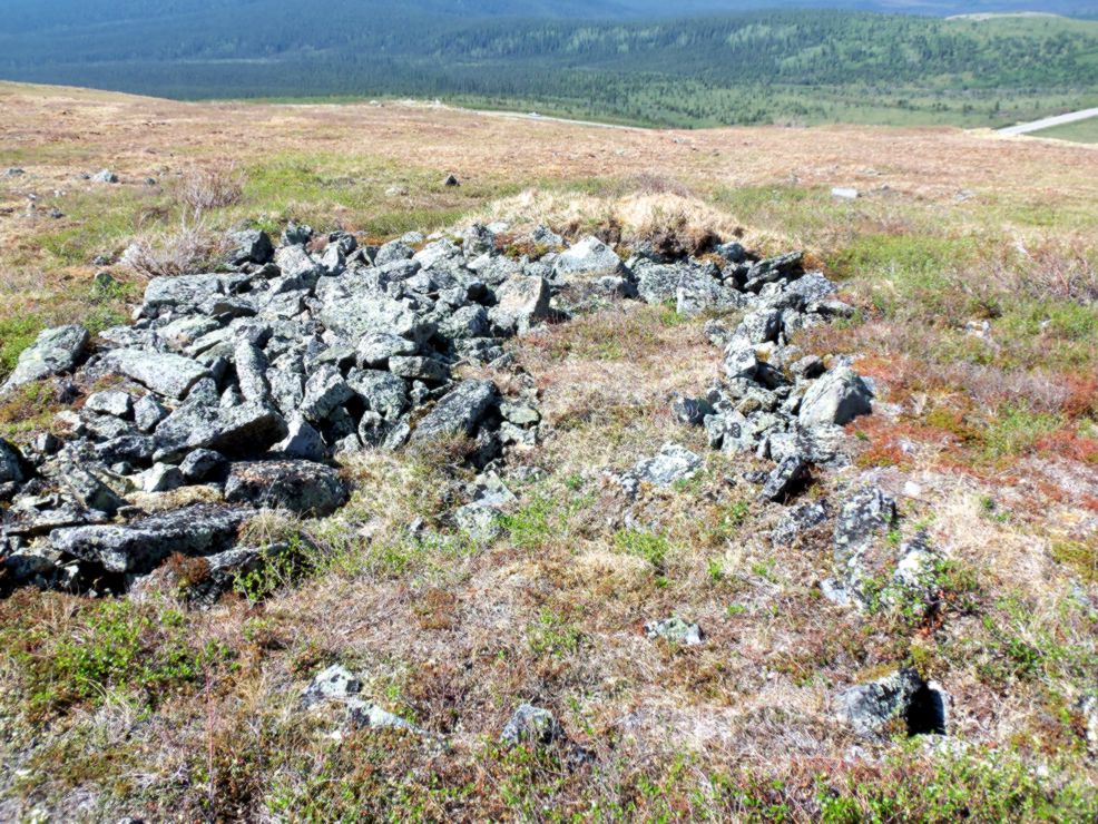 The flowing rocks here have pushed up the tundra moss
like a bulldozer pushing earth. All of this slow rock and soil
creep mean geologic contacts on our maps are rough
approximations. Geologists must sometimes live with imprecision
like this. That's one of the things that geology an unusual
science - working in extremely complex systems with only limited data
to try to arrive at the most precise, predictive model possible.
I imagine biology and biochemistry might be similar in nature because
there are so many interactions.
The flowing rocks here have pushed up the tundra moss
like a bulldozer pushing earth. All of this slow rock and soil
creep mean geologic contacts on our maps are rough
approximations. Geologists must sometimes live with imprecision
like this. That's one of the things that geology an unusual
science - working in extremely complex systems with only limited data
to try to arrive at the most precise, predictive model possible.
I imagine biology and biochemistry might be similar in nature because
there are so many interactions.
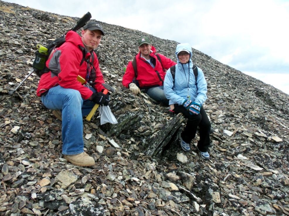
 In spite of differences in background, experience, ...
and, obviously, height,... Melania, Ken, and Dan got along better than
any group of
students with whom I've done field work. It was a pleasure
working with such positive people.
In spite of differences in background, experience, ...
and, obviously, height,... Melania, Ken, and Dan got along better than
any group of
students with whom I've done field work. It was a pleasure
working with such positive people.
The canister on Ken's belt is a can of
bear spray. Bear
spray is a very strong type of pepper spray that has been shown to
be effective at deterring bear attacks. Although we carried
firearms, those were just for use a last resort. We were the visitors tromping
around in the bear's home.
